月探査ガイド用ウェアラブルデバイスとは?
軽量のバックパックがナビする技術、すごいですね!!
早速、今日もVOAで英語を学びましょう!!
ワクワク!!
NASA、将来の月探査をサポートする’ルナ・バックパック’を開発(和訳)
NASA Develops ‘Lunar Backpack’ to Support Future Moon Exploration
May 08, 2022
アメリカの宇宙機関NASAが、将来の月探査をガイドするためのウェアラブルデバイスを開発しました。
このシステムは、地形図を作成し、月の未知の領域や暗黒地帯で宇宙飛行士を誘導するようにデザインされています。
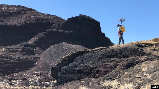
この装置は、バックパックとして身につけることができます。これは、Kinematic Navigation and Cartography Knapsackキネマティックナビゲーションおよびカートグラフィーナップザック(KNaCK)と呼ばれるものです。地球上にあるようなGPSシステムがない月での航行を支援するために、特別に設計されたシステムです。
KNaCKは、LiDARと呼ばれる技術を搭載し、リアルタイムに3D地図を作成します。LiDARは、センサーと光レーザーで周囲の環境をマッピングし、距離を測定する技術です。
NASAのエンジニアは、民間のパートナーと協力してこのシステムを開発しました。パートナーのひとつは、カリフォルニア州マウンテンビューにあるAeva社です。同社はLiDARセンサーを提供し、プロジェクトのサポートを行ったとNASAは述べています。
Aeva社はプレスリリースで、NASAに提供したセンサーはFMCWと呼ばれる技術を使用していると述べています。NASAによると、この技術により”1秒間に数百万の測定点”を提供し、ある地域の地形の高品質な地図を作成することができると言います。
同社は、太陽がFMCW技術に干渉することはなく、暗闇でも動作させることができると説明しています。これにより、宇宙飛行士や月面車が日中や夜間に月面を探査し、地図を作成するのに役立つと言います。
ジェームズ・ロイター氏は、Aeva社の技術担当副社長です。KNaCKシステムは、"宇宙飛行士がNASAのアルテミスプログラムの重要な目標を遂行するのを助ける "重要なものになると彼は言います。
アルテミスとは、NASAが月に人類を帰還させるために行っているプログラムです。2025年までにアメリカ人宇宙飛行士を月面に着陸させることを目標としています。1972年のアポロ17号の着陸以来、人類が月を訪れるのは初めてとなります。
アラバマ州ハンツビルにあるNASAマーシャル宇宙飛行センターでKNaCKプロジェクトを率いるマイケル・ザネッティ氏は、この装置について次のように述べています。同氏は、この装置は、測量作業や自動車の運転支援ツールに使用されているレーザーベースの技術の”超強力版”のようなものだと述べています。
ザネッティ氏は、KNaCKは宇宙飛行士がナビゲーション操作とサイエンスマッピングの両方に使用できると指摘します。「また、月のようなGPSが使えない環境では、宇宙飛行士やローバー車の安全確保にも役立ちます。」と述べています。
ザネッティ氏は、このシステムが探検家に「どこまで来たか、目的地まであとどれくらいか」を示すリアルタイムの地図を提供することができると付け加えます。
NASAはまた、アラバマ州に拠点を置くTorch Technologies Inc.と協力して、実用的なモデルのKNaCKバックパックを開発しました。この装置は、ニューメキシコ州キルボーン・ホールのNASA研究センターなど、いくつかの環境でテストされています。このセンターは、月と同じような地形を持つ火山クレーターの近くにあるため、月の研究に利用されています。
宇宙機関は、この装置が将来の月面探査活動の重要な一部になる可能性があるとしています。特に、宇宙飛行士が月の南極を訪れる際には、その可能性があります。NASAは、この地域に探検家を送り込みたいと考えています。しかし、そこは太陽光がほとんど当たらず、宇宙飛行士が航行するのは難しいものです。
開発チームは、次にKNaCKを小型化することに取り組むと言います。現在のバックパック型は約18キログラム。持ち運びしやすいように、ソーダの容器くらいの大きさを目指しています。
また、宇宙空間に存在する微小重力や放射線の影響から、デバイスの繊細な電子システムを保護する方法を模索中です。
NASA Develops ‘Lunar Backpack’ to Support Future Moon Exploration
The American space agency NASA has developed a wearable device to guide future explorers on the moon.
The system is designed to map terrain and guide astronauts through unknown territory and dark areas of the moon.
The device can be worn as a backpack. It is called the Kinematic Navigation and Cartography Knapsack, or KNaCK. The system was specially designed to provide navigation assistance on the moon, which lacks the kinds of GPS systems that exist on Earth.
KNaCK is equipped with a technology called LiDAR to produce real-time, 3D maps. LiDAR uses sensors and light lasers to map the surrounding environment and measure distances.
NASA engineers worked together with private partners to develop the system. One of the partners is Aeva Inc. of Mountain View, California. The company supplied LiDAR sensors and support for the project, NASA said.
The sensors it provided to NASA use a technology known as FMCW, Aeva said in a press release. NASA says the technology can provide “millions of measurement points per second” and create a high-quality map of an area’s terrain.
The company explained that the sun does not interfere with FMCW technology and it can operate in darkness. This can help astronauts and moon vehicles explore and map the lunar surface during the day or at night.
James Reuther is the vice president of technology at Aeva. He said the KNaCK system will be important “to help astronauts carry out critical objectives of NASA’s Artemis program.”
Artemis is NASA’s program to return humans to the moon. It aims to land American astronauts on the moon by 2025. It would mark the first time humans have visited the moon since NASA’s Apollo 17 landing in 1972.
Michael Zanetti leads the KNaCK project at NASA’s Marshall Space Flight Center in Huntsville, Alabama. He said the device is like a “superpowered version” of laser-based technologies used in surveying operations and driver-assistance tools for vehicles.
Zanetti noted that KNaCK can be used by astronauts for both navigation operations and science mapping. “It also will help ensure the safety of astronauts and rover vehicles in a GPS-denied environment such as the Moon,” he said.
Zanetti added that the system can provide real-time maps to show explorers “how far they’ve come and how far is left to go to reach their destination.”
NASA also worked with Alabama-based Torch Technologies Inc. to develop a working model KNaCK backpack. The device has been tested in several settings, including at a NASA research center in Kilbourne Hole, New Mexico. The center is used for lunar research because it is near a volcanic crater that contains terrain similar to the moon.
The space agency says the device can become an important part of future exploration activities on the moon. This could especially be true for astronaut visits to the moon’s South Pole. NASA wants to send explorers to this area. However, it receives little sunlight and would be difficult for astronauts to navigate.
The development team says it will next work to shrink the size of KNaCK. The current backpack model weighs about 18 kilograms. The goal is to produce a device that is about the size of a soda container for easy transportability.
Engineers are also working to find ways to protect the device’s sensitive electronics system from the effects of microgravity and radiation that exist in space.
Words in This Story
terrain – n. a particular kind of land
backpack –n. a bag for carrying things that has two shoulder straps and is carried on the back
navigate – v. to find the right direction for traveling by using maps or other equipment
GPS (global positioning system) – n. a radio system that uses signals from satellites to tell you where you are and to give you directions to other places
objective – n. something that you are trying to achieve
survey – v. to examine an area of land by taking measurements and recording details
destination – n. the place where someone or something is going
crater – n. a big hole in the ground created by the force of an object