次々と明らかになる証拠にワクワクが止まりませんね♬
火星に心を飛ばしましょう!!
::::::::::::
今宵は442年ぶり(安土桃山時代以来)の天体ショー!!
皆既月食は:月が地球の影に徐々に覆われていき、太陽と地球と月が一直線に並び、月全体が地球の影に完全に覆われます。
国立天文台によると、8日の午後6時9分ごろから月が欠け始め、7時16分から8時42の間、皆既食の状態となり、部分的に欠けた状態を経て9時49分ごろ明るい満月に戻るということです。
VOAで英語を学びましょう!!
火星に大規模な古代の海があることを示す新たな証拠(和訳)
New Evidence for Large Ancient Ocean on MarsNovember 06, 2022
November 06, 2022
研究者らは、火星にかつて大規模な北方海があったことを示す新たな証拠を発見したと発表しました。この発見は、古代の火星が何らかの生命を維持するのに適した条件を持っていたことを示す既存の証拠に追加されます。
現在、火星は寒冷な砂漠気候である。火星の気温は非常に低いため、水分は氷の形で存在すると考えられています。しかし、かつて火星に川や湖、さらには海が存在したことを示唆する証拠は豊富にあります。
例えば、アメリカの宇宙機関NASAが2015年に行った研究では、43億年前の火星には、火星の北半球の半分近くを覆う海があった可能性が高いことが示唆されています。
また、1月に発表されたNASAが支援する別の研究では、30億年前、火星の北半球の大部分は現在の地球と非常に似た気候であったと推定しています。この研究では、当時の火星は現在よりもはるかに厚い大気を持ち、活発な北半球の海があった可能性が高いと指摘されています。
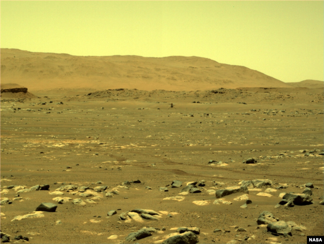
NASAの火星探査機マーズ・パーセバランスが搭載している右ナビゲーションカメラ(ナブカム)で撮影した画像。2021年4月21日に受信された。(画像出典:NASA/JPL-Caltech)
このたび、アメリカの2人の研究者が、火星の低地にある北半球に大規模な古代の海があったことを示す新たな環境証拠を示すとする地図群を発表しました。
研究チームは、火星の衛星画像からデータを収集しました。そして、これらの画像を組み合わせて、火星の北半球のtopography 地形図を作成しました。
この地図を使って、約35億年前に巨大な水塊の端にあった海岸線の証拠をつなぎ合わせることができたと研究者らは言っています。
この成果は、Journal of Geophysical Research誌:惑星:に掲載されました。

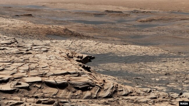
この画像は、ペンシルベニア州立大学の科学者が率いる研究者たちによって行われた火星の研究の結果で、彼らは、この惑星がかつて大規模な北方海域を持っていたという証拠を示す地図を作成したと言っている。(画像出典:Benjamin Cardenas/Penn State)
研究チームは、米国地質調査所が開発したソフトウェアを使用して、NASAが運営する宇宙船が収集したデータをマッピングしたと言います。その結果、水が流れてできたとされる6,500キロメートル以上の尾根が発見されました。
科学者たちは、このridge尾根が、eroded浸食された河川システムや古代の海底の名残である可能性が高いと言います。研究チームは、今回の調査で大量のsediment堆積物があることも示唆され、大規模な海洋のさらなる証拠となると言っています。
ベンジャミン・カルデナス氏はこの研究の共同執筆者です。彼はペンシルバニアにあるペンシルバニア州立大学の地球科学の教授です。彼は、現在Aeolis Dorsaとして知られているー火星の研究領域ーの声明の中で、地球上で水が形成された尾根の”最も密集したコレクション”を含むと述べています。
カルデナス氏は、この研究結果は、火星のその領域にある可能性のある海が非常に活発で興味深いものであることを示していると述べています。「それはダイナミックなものでした。海水面は著しく上昇しました。」と彼は述べます。「そのbasin 盆地に沿って岩石がat a fast rate高速で沈殿していました。ここでは多くの変化が起きていたのです。」
カルデナス氏は、私たちの惑星にある水で形成された尾根や堆積物を含む地域は、その地域の気候や生命体について研究者に多くの有益な情報を提供すると付け加えました。「もし科学者が火星の生命の記録を見つけたいなら、かつてエオリス・ドルサを覆っていたような大きな海が、最も論理的な出発点になるでしょう」と彼は言いました。
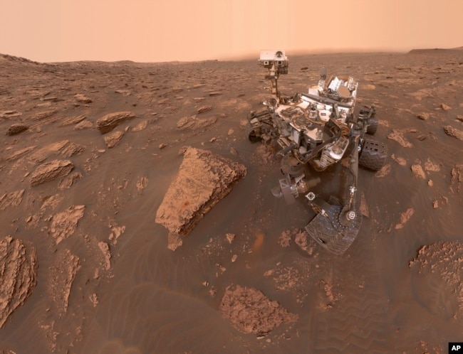
2018年6月15日の一連の写真から作られたこの合成画像は、ゲール・クレーターにいるNASAの火星探査機キュリオシティの自画像です。(NASA/JPL-Caltech via AP)
研究チームは、NASAの火星探査機Curiosity, キュリオシティの大きな目標は、火星に古代の生命の痕跡を探すことであると指摘しています。現在、キュリオシティは火星の南半球にあるゲール・クレーター内で活動しています。過去には、ゲール・クレーター周辺で過去の水系の証拠も見つかっています。
大規模な海洋のさらなる証拠を提供するだけでなく、カルデナス氏は、新しい研究が火星の古代の気候と発達の歴史に関する有益な情報を提供することを示唆しています。「これらの発見に基づいて、私たちは、一度にこれだけの液体の水を支えるのに十分なほど暖かく、大気が厚い時期があったはずだとわかっています」と彼は言いました。
New Evidence for Large Ancient Ocean on Mars
Researchers say they have discovered new evidence that Mars once had a large northern ocean. The finding adds to existing evidence that ancient Mars had the right conditions to possibly support some form of life.
Today, Mars has a cold, desert climate. Any water is believed to be in the form of ice because of the planet’s extremely cold temperatures. But there is a rich amount of evidence suggesting that rivers, lakes and even oceans once existed on Mars.
For example, a 2015 study by the American space agency NASA suggested that 4.3 billion years ago, Mars likely had an ocean that covered nearly half of Mars’ northern hemisphere.
Another NASA-supported study, published in January, estimated that three billion years ago, the climate in much of the planet’s northern hemisphere was very similar to present day Earth. The study noted that at the time, Mars likely had a much thicker atmosphere than today and had an active, northern ocean.
Now, two American researchers have released a set of maps they say provides new environmental evidence of a large ancient ocean on Mars’ low-lying northern hemisphere.
The team collected data from satellite images of Mars. They then combined these images to create topography maps of the planet’s northern hemisphere.
Using these maps, the researchers said they were able to piece together evidence of shorelines that sat at the edge of a huge body of water about three-and-a-half billion years ago.
The scientists recently published their findings in the Journal of Geophysical Research: Planets.
The team said it used software developed by the United States Geological Survey to map data collected by spacecraft operated by NASA. The research uncovered more than 6,500 kilometers of ridges that are believed to have been formed by flowing water.
The scientists say the ridges likely represent the leftover evidence of eroded river systems and an ancient ocean floor. The team said its research also suggested large levels of sediment, providing further evidence of a large ocean.
Benjamin Cardenas was a co-writer of the study. He is a professor of geosciences at Penn State University in Pennsylvania. He said in a statement the area of Mars studied – now known as Aeolis Dorsa – contains “the densest collection” of water-formed ridges on the planet.
Cardenas said the study’s findings demonstrate the possible ocean in that area of Mars was very active and interesting. “It was dynamic. The sea level rose significantly,” he said. “Rocks were being deposited along its basins at a fast rate. There was a lot of change happening here.”
Cardenas added that areas on our own planet containing water-formed ridges and sediment provide researchers with much useful information about an area’s climate and life forms. “If scientists want to find a record of life on Mars, an ocean as big as the one that once covered Aeolis Dorsa would be the most logical place to start,” he said.
The team noted that the major goal of NASA’s Mars explorer, Curiosity, is to look for signs of ancient life on the planet. Currently, Curiosity is operating within the planet’s Gale Crater, which is in the southern hemisphere of Mars. In the past, researchers have also found evidence of past water systems around Gale Crater.
In addition to providing more evidence of a large ocean, Cardenas suggested the new study also provides useful information on Mars’ ancient climate and developmental history. “Based on these findings, we know there had to have been a period when it was warm enough and the atmosphere was thick enough to support this much liquid water at one time,” he said.
Words in This Story
topography – n. the shape and other physical characteristics of a piece of land
shoreline – n. the edge of a sea, lake or wide river
ridge – n. a long, narrow piece of land
erode – v. to rub away over time
sediment – n. the material that sinks to the bottom of a liquid
dynamic – adj. continuously changing or developing
deposit – v. to leave something somewhere
logical – adj. reasonable and based on good judgment