美しきハワイ:燃える火山

上記に貼り付けたappで音声をお聞きください。
Hawaii Volcanoes National Park: A Fiery World
April 15, 2025
EDITOR'S NOTE: This year, the U.S. National Park Service turns 100. American's 28th President, Woodrow Wilson, formed the National Park Service in 1916 to “protect the wild and wonderful landscapes” in the United States. Today, the National Park Service protects over 400 parks and historical sites from coast to coast. Every week, VOA Learning English will profile one of the sites within the National Park Service.
Our national parks journey this week takes us to the middle of the Pacific Ocean and America's 50th state. We are exploring the unique and fiery world that is Hawaii Volcanoes National Park.
Most people would say that the tallest mountain on Earth is Mount Everest, near the border between Nepal and Tibet.
But there exists a mountain that is 300 meters taller than Mount Everest. Most of it is underwater, however. It begins at the bottom of the Pacific Ocean, and rises more than 17 kilometers from the ocean floor. Its name is Mauna Loa.
In the Hawaiian language, Mauna Loa means “Long Mountain.” Mauna Loa makes up more than half of the island of Hawaii, one of the eight major Hawaiian Islands.
Mauna Loa is the largest volcano on Earth. It last burst in 1984. Today, Mauna Loa is quiet. But volcano experts say it is only a matter of time before it bursts again.
Mauna Loa is one of two volcanoes within Hawaii Volcanoes National Park. The other is Kilauea. It is the most active volcano in the world. Red-hot liquid rock, or lava, has continuously flowed from Kilauea since 1983.
Most of the time, the lava appears to move peacefully toward the ocean. But it is not as peaceful as it seems from a distance. In 2014, the lava flowed through one small town on the island. It slowly covered the town, blocking and destroying roads.
Nothing can stop the lava of Kilauea.
When the lava reaches the ocean, its fierce heat produces steam. The lava is so hot that it continues to burn underwater. It cools and hardens over time, creating new land.
This volcanic action is what formed, and continues to form, the Hawaiian Islands.
Shaping the land
That volcanic action is one of many unusual features at Hawaii Volcanoes National Park.
The park's volcanic landscape is almost otherworldly. In fact, NASA uses the top of Mauna Loa to simulate life on Mars for researchers.
The national park has seven ecological areas, including woodlands, rainforests, and even snowy climates.
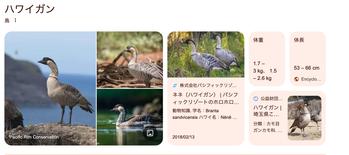
It is home to many native plants and animals. Many endangered species live within the park, such as the hawksbill turtle, the Hawaiian hawk and
Hawaiian goose, or nene.
Evidence of Hawaii's native culture is preserved at the park. The park includes remains of the homes and other structures used by the ancient people of the islands.
There are also thousands of petroglyphs created thousands of years ago. Petroglyphs are images carved into rock. The images help explain the living conditions and traditions of the ancient Hawaiians.
Hawaiian legend places Mauna Loa at the center of the spiritual world. Pele is the goddess of the volcano. In one traditional story, Pele tries to win the love and attention of the husband of her sister, the sea goddess. Her sister becomes very angry, making powerful ocean waves and floods. Pele seeks a safe place to avoid the punishment. She finally arrives at Mauna Loa. It is so tall that the water cannot threaten her. The volcano goddess makes Mauna Loa her home.
The U.S. National Parks Service works to protect these natural landscapes important to today's Hawaiians and to their ancestors.
Visiting the volcanoes
More than 1.5 million people visit Hawaii Volcanoes National Park each year.
Visitors can experience the park's volcanoes in several ways. Some people fly over the volcanoes in airplanes or helicopters. This is a safe and popular way to watch Kilauea's lava moving slowly toward the ocean.
Visitors can also explore Kilauea's Crater Rim Drive. The crater is the round area that leads down to a volcano. The Crater Rim Drive is 18-kilometers around.
Adventure-seeking travelers may wish to climb to the top of the park's other volcano, Mauna Loa. It is considered the world's largest single mountain. The Mauna Loa Trail climbs almost 35 kilometers to the volcano's summit. There is no shade or protection from the strong Hawaiian sun.
Most hikers can climb the trail in two days.Mauna Loa's summit is almost always cold, and often snowy. Hikers can stay in a simple house at the top of the mountain before they begin the trip back down.
The park has shorter hikes, as well, including the 2-kilomoeter Pu'u
Petroglyphs Trail.Visitors walk through lava fields filled with petroglyphs. The
images document the life and culture of native Hawaiians.
The Devastation Trail winds through a part of the park that was destroyed by the 1959 eruption of the Kilauea Iki crater. During the burst, hot ash and huge pieces of volcanic rock, called pumice, fell on the area. The forested area, thick with trees, was burned.Today, plant life is returning.
The Devastation Trail is near another interesting site within the park: the Thurston Lava Tube. A 20-minute walk through a forest leads to a cave-like tube. The lava tube was discovered in 1913.
Today, visitors can walk through it. A path of lights marks the way.
But hundreds of years earlier, a fierce river of red lava rushed through the tube, another reminder of the ever-changing and violent nature of Hawaii's volcanoes.
ハワイ火山国立公園 炎の世界(和訳)
編集者注:今年、アメリカ国立公園局は100周年を迎えます。アメリカの第28代大統領ウッドロー・ウィルソンは、1916年にアメリカ国内の”野生的で素晴らしい景観を保護する”ために国立公園局を設立しました。今日、国立公園局は海岸から海岸まで400以上の公園や史跡を保護しています。VOAラーニング・イングリッシュでは、毎週、国立公園局内の1つの場所を紹介します。
今週の国立公園の旅は、太平洋の真ん中、アメリカ50番目の州を訪れます。ハワイ火山国立公園というユニークで燃えるような世界を探検します。
地球上で最も高い山は、ネパールとチベットの国境近くにあるエベレストだと言う人がほとんどでしょう。
しかし、エベレストよりも300メートル高い山が存在します。ただし、そのほとんどは海中にあります。それは太平洋の海底から始まり、海底から17キロ以上そびえ立っています。その名はマウナロア。
ハワイ語でマウナロアは ”長い山 ”を意味します。マウナロアはハワイ島の半分以上を占め、8つの主要なハワイ諸島のひとつです。
マウナロアは地球上で最大の火山です。最後に噴火したのは1984年。現在、マウナロアは静かです。しかし、火山の専門家は、再び噴火するのは時間の問題だと言います。
マウナロアは、ハワイ火山国立公園内にある2つの火山のうちのひとつです。もうひとつはキラウエア火山です。世界で最も活発な火山です。1983年以来、キラウエア火山からは赤熱した液体の岩石、つまり溶岩が流れ続けています。
ほとんどの場合、溶岩は穏やかに海に向かって移動しているように見えます。しかし、遠くから見るほど平和ではありません。2014年、溶岩は島のある小さな町を流れ出ました。溶岩はゆっくりと町を覆い、道路を塞ぎ、破壊しました。
キラウエアの溶岩を止めることはできません。
溶岩が海に到達すると、その猛烈な熱によって水蒸気が発生します。溶岩はとても熱いので水中で燃え続けます。溶岩は時間とともに冷えて固まり、新しい陸地を作り出します。
この火山活動がハワイ諸島を形成し、今も形成し続けています。
大地の形成
この火山活動は、ハワイ火山国立公園の珍しい特徴のひとつです。
ハワイ火山国立公園の火山景観は、まるで別世界otherworldlyのようです。実際、NASAは研究者のためにマウナロアの頂上を使って火星での生活をシミュレーションしています。
この国立公園には、森林地帯、熱帯雨林、さらには雪気候を含む7つの生態系エリアがあります。
この国立公園には、多くの固有の植物や動物が生息しています。タイマイ、ハワイアン・ホーク、ハワイアン・グース(ネネ)など、絶滅危惧種の多くが公園内に生息しています。
ハワイアン・グース(ネネ)。
公園内にはハワイ先住民の文化が残されています。公園内には、ハワイ諸島の古代人が使用していた住居やその他の建造物の遺跡があります。
数千年前に作られたペトログリフもあります。ペトログリフとは、岩に刻まれた絵のことです。ペトログリフは、岩に刻まれた絵のことで、古代ハワイアンの生活環境や伝統を説明するのに役立ちます。
ハワイの伝説では、マウナロアは精神世界の中心に位置しています。ペレは火山の女神です。ある伝統的な物語では、ペレは姉である海の女神の夫の愛と関心を得ようとします。姉は非常に怒り、強力な海の波と洪水を起こします。ペレは罰を避けるために安全な場所を探します。そしてついにマウナロアにたどり着きます。マウナロアはとても高く、海がペレを脅かすことはありません。火山の女神はマウナロアを住処とします。
アメリカ国立公園局は、現在のハワイの人々にとっても、彼らの祖先にとっても重要なこれらの自然景観を保護するために活動しています。
火山を訪れる
毎年150万人以上がハワイ火山国立公園を訪れます。
訪問者はいくつかの方法で公園の火山を体験できます。飛行機やヘリコプターで火山上空を飛ぶ人もいます。これは、キラウエアの溶岩が海に向かってゆっくりと移動していく様子を見る安全で人気のある方法です。
また、キラウエアのクレーター・リム・ドライブを探検することもできます。火口とは火山につながる丸い部分のことです。クレーター・リム・ドライブは一周18キロ。
冒険好きな旅行者は、公園のもうひとつの火山、マウナロアの頂上に登ってみたいと思うかもしれません。マウナロアは世界最大の単独峰です。マウナロア・トレイルは、火山の頂上summitまで約35キロを登ります。ハワイの強い日差しを遮るものはありません。
ほとんどのハイカーは2日でトレイルを登ることができます。マウナロアの山頂は常に寒く、雪が降っていることも多くあります。ハイカーは下山する前に山頂の簡素な家に泊まることができます。
マウナロア公園には、2キロメートルのプウ・ペトログリフ・トレイルなど、短いハイキングコースもあります。
ペトログリフ・トレイル(Petroglyphs Trail)は、ペトログリフで埋め尽くされた溶岩地帯を歩くコースです。ペトログリフは ハワイ先住民の生活や文化が記録されています。
デバステーション・トレイルは、1959年のキラウエア・イキ火口の噴火によって破壊された公園の一部を曲がりくねって通ります。噴火の際、高温の火山灰と軽石pumiceと呼ばれる巨大な火山岩の破片がこの地域に降り注ぎました。木々が生い茂る森林地帯は焼け野原となったのです。
デバステーション・トレイルは、公園内のもうひとつの興味深い場所:サーストン溶岩洞窟Tubeの近くにあります。森の中を20分ほど歩くと、洞窟のようなチューブにたどり着きなす。この溶岩洞窟は1913年に発見されました。
今日、観光客はその中を歩くことができます。光の道が目印です。
しかし、その何百年も前には、赤い溶岩の激しい川が洞窟を駆け抜け、ハワイの火山が常に変化し、激しい性質を持つことを改めて思い知らされreminderました。