トンガの火山噴火、海への影響を計測予定
本当に、トンガの火山噴火には驚きました!!一時はその噴煙が地球を覆うのではないかと危惧したほどでした。
紺碧の海に囲まれ、緑の島への復興を切にながっています!!
VOAで英語を学びましょう!!
トンガの火山による海への影響を計測するロボットボートが登場 (和訳)
Robotic Boat to Help Measure Sea Effects of Tonga Volcano
April 11,2022
1月に起きた海底火山の爆発が周辺の海に与えた影響を測定するため、科学者チームがトンガへ向かっています。その一環として、チームはロボットボートを使って、海底の詳細な地図の作成に協力する予定です。
フンガトンガ・ハアパイ火山の爆発、噴火は、過去30年間における世界最大級の規模でした。
南太平洋の島国で起きたこの噴火では、煙とガスが上空30キロメートルにまで噴き上がりました。また、津波と呼ばれる海の波が太平洋全域に発生しました。ロイター通信によると、波の高さは最大で15メートルに達したものもあるということです。
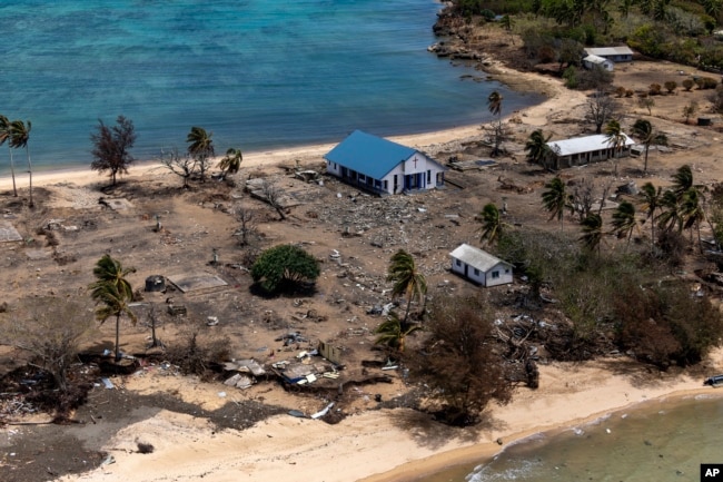
FILE - オーストラリア国防軍提供、2022年1月28日、海底火山の噴火とそれに伴う津波で、破損した建物の破片や樹木が散乱するトンガのアタタ島の写真。
この噴火と津波により、トンガでは少なくとも3人が死亡し、多数の家屋や通信設備が破壊されました。トンガ政府によると、爆発の影響は遠く南米まで及んだと言います。
トンガに向かうチームは、音響・映像機器やその他の科学機器を使用して、爆発の海中への影響を調査する予定です。このプロジェクトは、ニュージーランドの国立水・大気研究所(NIWA)と日本の非営利団体である日本財団の共同作業です。
NIWAのプレスリリースによると、科学者たちは噴火の影響について”数千平方キロメートルの海底を調査し、ビデオ画像を収集”する予定です。
このプロジェクトのリーダーは、NIWAの主任海洋科学者であるマイク・ウィリアムス氏です。同氏は、トンガ周辺の海底と海洋生物に広範な変化が見られるだろうと予測しています。
「噴火前、火山の大部分は水面上にありました。しかし、今ではそのどれもが水面上に出ておらず、隣接するフンガトンガ島とフンガハパイ島は縮小しています。」とウィリアムズ氏は述べています。また、海底の地図作成でも”同様の劇的な”変化が見られると予想されると付け加えています。
ウィリアムズ氏によると、海底通信線の被害は、噴火の影響が火山の中心から50キロメートルまで及んだことを示唆しているとのことです。つまり、少なくとも8,000平方キロメートルの範囲の海洋生物に影響を与えた可能性が高いということです。
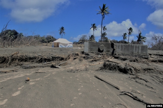
FILE - 2022年1月23日、トンガのカノクポルで起きた火山噴火と津波の後、被害を受けた建物と火山灰で覆われた風景を示す全景。(トンガ赤十字社/Handout via Reuters)
科学者たちは、”エコーサウンダー”と呼ばれる装置で水中音のデータを収集します。この装置は、水中景観の形や構造をマッピングするために設計されているとNIWAは述べています。
ウィリアムズ氏はFacebookで公開されたオンラインビデオで、科学者たちは海底の広い範囲を調査するビデオシステムも配備すると述べています。これは、火山からの瓦礫がその地域の海洋生物にどのような影響を与えたかを確認するのに役立つはずです。
チームはNIWAの調査船でトンゴに向かい、2週間余りをその地域で過ごす予定です。
また、ロボットボートを使って環境データを収集し、被災地の詳細な地図作成作業を行う予定です。マックスライマーと呼ばれるこのボートは、英国の管制官の指導のもとで走行します。管制官は、このボートを製造したイギリスの企業、SEA-KIT Internationalに所属しています。マックスライマー号は最大で30日間、被災地の調査を続けることになっています。
ベン・シンプソン氏は、SEA-KITインターナショナルの代表です。彼は声明の中で、トンガの地図作成作業は、海洋でロボット測量機器を使うことの利点を示すのに良いプロジェクトだと述べています。シンプソン氏は、Maxlimerは乗組員を必要とせず、燃料消費量も一般的な調査船の2%以下であることを指摘してします。
Robotic Boat to Help Measure Sea Effects of Tonga Volcano

A scientific team is headed to Tonga to measure the effects of January’s undersea volcano explosion on the surrounding ocean. As part of the project, the team will use a robotic boat to help create a detailed map of the sea floor.
The explosion, or eruption, of the Hunga Tonga Hunga Ha’apai volcano was among the world’s largest in the past 30 years.
The eruption on the South Pacific island nation sent smoke and gas shooting 30 kilometers into the air. It also created ocean waves, called tsunamis, that formed across the Pacific Ocean. Some of the waves were up to 15 meters high, Reuters news agency reported.
The eruption and tsunamis led to at least three deaths in Tonga and destroyed numerous homes, as well as communications equipment. Tonga’s government said the effects of the explosion were felt as far away as South America.
The team going to Tonga will use sound and video equipment and other scientific instruments to examine the undersea effects of the explosion. The project is a joint effort between New Zealand’s National Institute of Water and Atmospheric Research (NIWA) and Japan’s non-profit Nippon Foundation.
The scientists will be “surveying thousands of square kilometers of the seafloor and collecting video images” of the eruption’s effects, said a recent press release by NIWA.
The leader of the project is Mike Williams, the chief ocean scientist for NIWA. He predicts the team will find widespread changes to the ocean floor and sea life in areas around Tonga.
“Before the eruption, much of the volcano was above water. But now none of it is and the neighboring islands of Hunga Tonga and Hunga Ha'apai were reduced in size,” Williams said. He added that the team expects to find “similarly dramatic” changes when mapping underwater areas.
Williams said the damage to undersea communication lines suggests the effects of the eruption stretched up to 50 kilometers from the volcano’s center. This means the explosion likely affected ocean life in an area of at least 8,000 square kilometers.
The scientists will gather underwater sound data from devices known as “echosounders.” The equipment is designed to map the shape and structure of the underwater landscape, NIWA said.
In an online video published on Facebook, Williams said the scientists will also deploy a video system that will survey wide areas of the seabed. This should help the team see how debris from the volcano has affected sea life in the area.
The team will travel to Tongo aboard a NIWA research ship and will spend a little over two weeks in the area.
The researchers will also use a robotic boat to collect environmental data and carry out detailed mapping operations of affected areas. The boat, called Maxlimer, will be guided by controllers in Britain. The controllers are with SEA-KIT International, the British company that built it. The Maxlimer is set to keep surveying the area for up to 30 days.
Ben Simpson is the head of SEA-KIT International. He said in a statement the Tonga mapping operation is a good project to demonstrate the benefits of using robotic surveying equipment in the ocean. Simpson noted that the Maxlimer needs no crew and uses less than 2 percent of the fuel needed for most research ships.
Words in This Story
survey – v. to look at or examine something carefully
dramatic – adj. very sudden or noticeable
debris – n. loose pieces of waste or remains
benefit – n. a good or helpful result